Bha’ach Ard - 862m (photo below) is a Corbett mountain peak that we can see from our home and I’ve longed to have a suitable opportunity to hike to the top and check out the views.

Well, the opportunity came this particular weekend in March as a high pressure weather system settled to the east of the UK and brought with it stable conditions and warmer temperatures. A lot of the snow had melted over the mountain, removing any challenges of the snow/ice category - and just leaving the challenge of my fitness levels.
I was planning to get to the car park around sunrise and was slightly later than intended. It would have been great to be at the top itself for sunrise, but realistically I wanted to check the route and type of hike it would be, before thinking of making a night hike of it!
The weather was superb. What a beautiful still morning it was, with the sunlight breaking through the trees and a clear view of the top from the lane that heads up Glen Strathfarrar. There was almost no wind at all, with reflections on the river as we headed for the power station where we needed to take a track northwards, about 1.1 miles from the car.


Photography-wise this hike was going to be slightly different than previous ones. The DSLR was packed away in the rucksack with the intent of using the Panasonic LX7 (stored in a pocket on the rucksack belt) to record different parts of the walk to avoid the continual stopping and unloading of camera gear. I planned to use the DLSR and longer zoom to get some decent photos from the summit when we got there.
We reached the power station in about 20 minutes and turned right, to head up the lane and started the ascent from ‘ground zero’ at the river - then remembering to start my Garmin watch to record the hike!
This part of the journey started fairly non-strenuous, but it wasn’t long before the track started to gain elevation and gave me a gentle easing into what lay ahead, with some nice views on the way!


The route instructions on the Walkhighlands website indicated to look out for a ATV track towards the end of the track I was on, which I completely missed and ended up at a dam where I realised I had gone too far. Not knowing how far back the ATV track was I looked across to the mountain peak in the distance and decided just to head straight towards it - the shortcut!

Then the hard work really started. The ground was soft (an understatement!) and full of heather and large mounds of thick grasses and was very heavy going, especially on the soles of my feet and ankles! Despite my regular hill running each week and cycle rides, I obviously have a lot further to go before this sort of hike was going to get easier! Or maybe it was something to do with age!
I lost Willow at one point (she must have been covering at least 5 times the distance I was walking with her tracking down all the scents). There was no sight or sound of her and no response when using the whistle. What seemed like ages, but probably was 5-10 minutes, I eventually saw her up the other side of the glen on her way back!! No idea where she had gone, but she seemed a little concerned as though she had lost me when we finally met up again!!
The rest of the climb was real tough. It was definitely a case of just focussing on one step in front of the other, determined to reach the summit and not ‘leave it for another day’. Eventually the final stages of the ascent were reached and we made it to the trig point at the top where it was blowing a hoolie! Thankfully there is a circular wall of rocks around the trig point and I hunkered down, getting the down jacket and waterproof from the rucksack to try and get some body warmth and protection as well as a drink from the flask before unloading the camera gear.
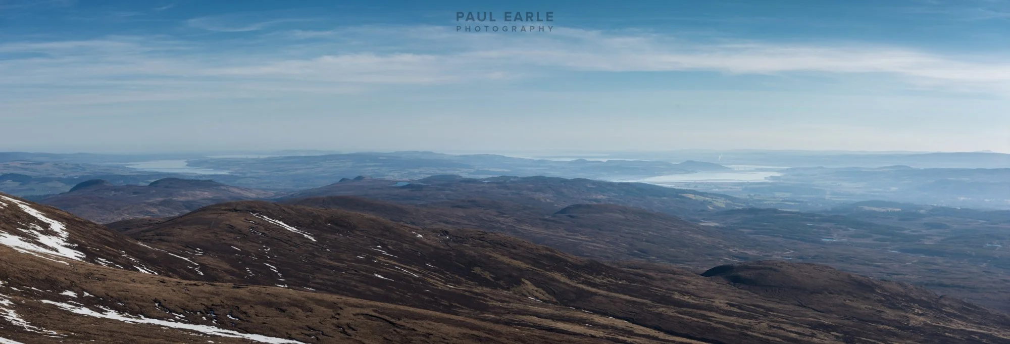
Then the fun began. The views made it all worthwhile. The sun had risen quite high and disappointingly there was a lot of haze as shown with the photos below. But even so, to just look around in every direction and see for miles was very special.
This was the hazy view across to Beauly Firth and Moray Firth and the Kessock Bridge:
And in the opposite direction just mountain peak, after mountain peak with the munros snow capped.
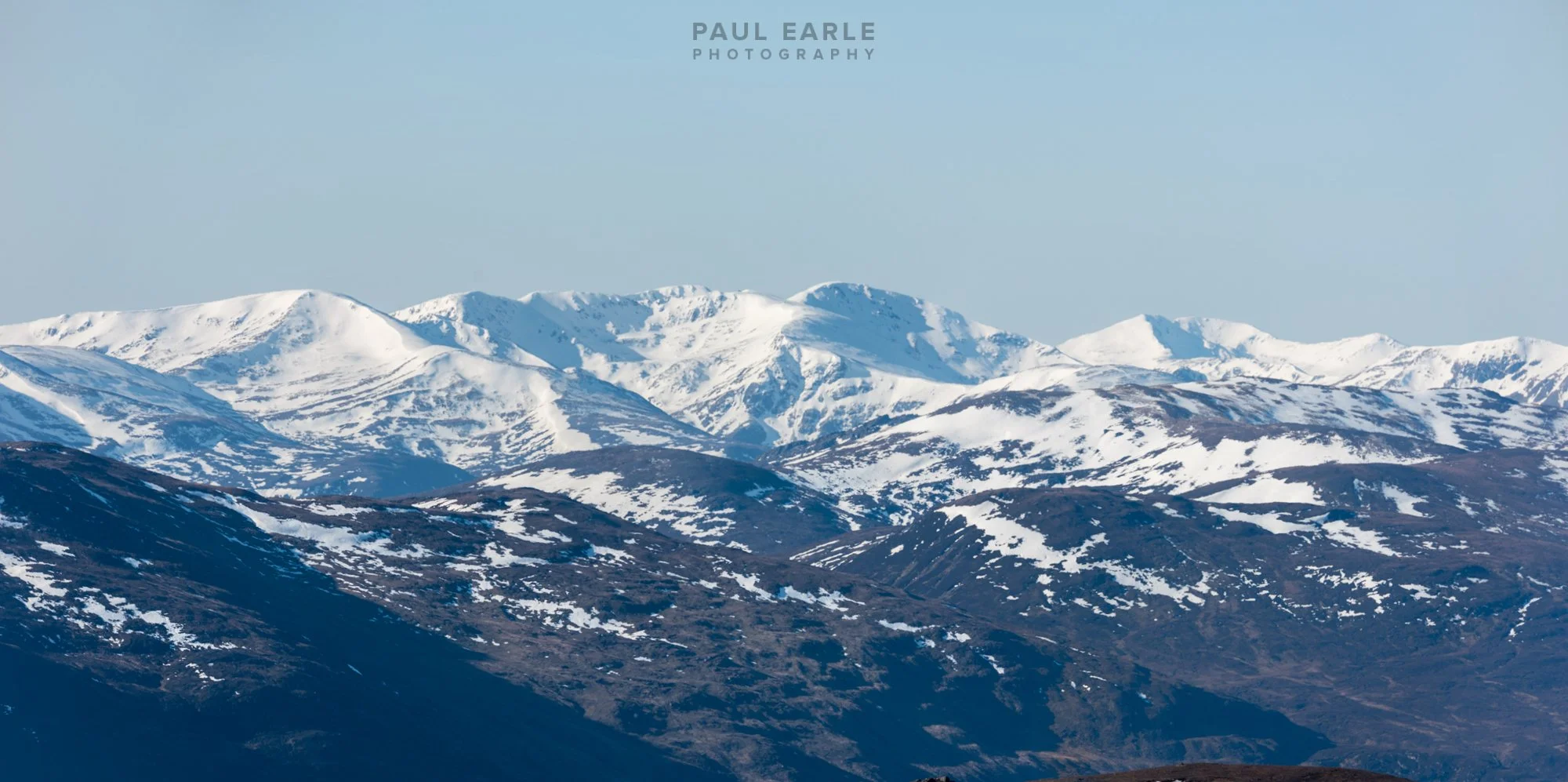


The views were stunning.


Layers of light were visible with the haze when looking across the multitude of peaks and ridges.


I couldn’t forget the obligatory photo of the trig point to prove I made it to the top!


It was time to head back - I could have taken the ridge route shown in the photo below, but with time of an essence due to plans for the afternoon, I kept to the original intention of retracing my steps down.

From the height of the summit I was able to make out the ATV track, which surprised me that it came so high up the mountain side, but it made the route back more straightforward, although much wetter.
By the time I reached the compressed gravel track, the soles of my feet were screaming and it felt like walking on course sandpaper the rest of the way back to the car. I did however stop for a photo of the final sighting of the munros in the distance as they started to be obscured by the tree line - nicely complemented by an electricity pylon! Maybe I’ll edit that out one day!

Back to the car at midday almost to the minute and job done! 10.7 miles from the car and just over 5 hours including the rest at the top when taking account of my late start of the Garmin app - Willow definitely made it clear she had done more than me!

